The purpose of this article is to explain the Layer settings in the Properties Menu.
To open the properties window
- Click on the properties icon (
 ) in the upper right-hand corner of the visualization bar OR
 - Click on the mouse pointer icon (
 ) in the navigation menu and then right click in your visualization and select properties
How do I create a layer?
To create a layer,
- Open the properties window of the 3d subsurface visualization
(Make sure the mouse pointer icon is selected.) - Select [+] Add in the lower left-hand corner of the properties window
- Select the type of layer to be added


Note: When adding the Seismic 3D layer: (Another visual control menu will appear)

In this menu, there is the inline for each axis and X, Y, Z Lines that can be configured for the Seismic 3D layer.
To hide the control menu, click "Close Controls"
How do I edit my layer?
To edit the properties of a layer,
- Open the Properties Window
- Click on the [+] to expand the Layers folder
- Under the Layers folder, select the layer to be edited
There are four tabs for editing each layer: General, Data, Positioning, Colors.
General tab- Edit the title and description of the layer here. Under Selection Options, turn on/off bounding box for marked items in the visualization.

Data tab - Select the data table and edit options for Marking, Data Limiting using Markings, and Data Limiting using filterings. Note: Always choose a filtering scheme to apply to the layer that corresponds with the visualization.

Positioning - Select the columns from the previously selected data table that contains the X, Y, Z coordinates, measured depth, surface designation, or trajectory designation.

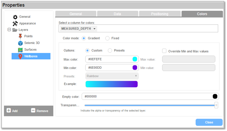
Colors - Select the column for colors in the layer, choose a color mode, and edit color options like color range and transparency of the layer.

How do I change the color properties of my layer?
To change the color properties of a layer,
- Open the Properties Window
- Under Layers, select the layer you wish to edit
- Go to the Colors tab
Choose a column in your data set that represents the Z (for Points and Surface layers) or Depth (for Wellbores layer).
Select a color mode: Gradient or Fixed.
If Gradient,
- Select a preset color scheme and click apply or
- Select custom to manually pick a color for the max and min value of your data column. You can also enter in a hex code for the color if you know it.
- See the Example color bar to view the result of your gradient.
If Fixed,
- Click on the color square to open the color palette
- Choose a fixed color for the layer
Empty Color refers to the color designated for the null values in the dataset.
Transparency refers to the opaqueness of the layer.
How do I delete a layer?
- Open the Properties Window
- Under the Layers folder, select the layer to be deleted
- Click [-] Remove
For additional information on 3D Subsurface documentation, click here